
The maximum extent of the brickworks outlined in red
Contents of this page
- The history of the brickworks
- People associated with the brickworks in the mid 19th century
- Other brick makers and burners in Whiteparish in 1841/1842
The history of the brickworks
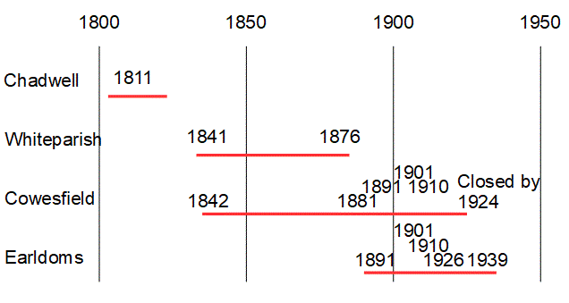
Whiteparish Brickworks was one of four brickworks in Whiteparish, the others being at Cowesfield, Chadwell and Earldoms. An introduction to all four can be found at Brickworks.
Map and census records of individual brickworks
Whiteparish brickworks was probably started in the 30 years after the Alderstone manor house by the church was demolished in 1812
Whiteparish brickworks ran from before 1842 to after 1876 and was closed by the time the OS 1:2500 map of 1901 was published. It was on the east side of Common Road south of the church, churchyard and the site of the Alderstone St Barbe manor house. The map below shows the 1842 (red) and 1876 (purple) outlines of the site on a modern map. The 1842 Common Road frontage is now the garden and drive of The Banks and there was a further access by 1876 just south of where the Croft Heights road joins Common Road. Steeple Barn, Church Rise, the pond and Memorial Centre lie immediately north of the northern boundary of the brickworks, with these two houses sharing the brickworks boundary on their south side. On this map the site of High Croft is shown shaded, the old house having been demolished and its replacement not yet built when the map was revised.
.gif)
The site of Whiteparish brickworks in 1842 (red) and 1876 (purple)
The three maps below show the progression of the brickworks site by repeating the outline of the site at two dates on each of three maps. The 1842 map on the left has been traced in red to show the outline of the site at that date. The central map is from 1876 and shows the expanded site traced in purple. The next map to the right is from 2025 to show how the site relates to the modern landscape. The fourth map shows the site boundaries over a geological map, with the pink/brown colour representing the London Clay Formation and blue the Reading Formation Sand. The brickworks site was entirely on the London Clay and it is interesting to note the adjacent pond next to the Memorial Hall. Although it is tempting to wonder whether this was dug for clay, it is much more likely to have been a garden feature of the Alderstone Manor House that stood on the plot to the north of the brickworks .


LEFT to RIGHT: Whiteparish brickworks in 1842, 1876, the site in 2025 and the geology [from Whiteparish brickworks.odg]
The outline of the site has been overlaid onto all four maps, red: 1842, purple: 1876
KEY to geology: Blue: Reading Formation Sand (66 to 56 million years ago); pink/brown: London Clay Formation (56 to 47.8 years ago)
The earliest view of the site is on the Tithe Award map of 1842 (the third map below), which shows the brickyard occupying just the parcel of land labelled 1254 (in two places) on the map. It was not shown on the 1773 Andrews and Drury map (left hand map below) and is not on the 1812 survey for the 1 inch Ordnance Survey maps (second map below), which does show the Chadwell brickworks. The Alderstone Manor House immediately to the north was demolished in 1812 and moved to Broxmore - this is the building below the church on the 1773 map below, with the gap below that being where the brickworks would be later. It seems unlikely that the brickworks would have been operated when the manor house was still there, narrowing the probable establishment date for the brickworks to later than 1812 and earlier than 1842.


Before and after: 1773,1812, 1842 and 20th century (Blaxwell is misplaced on the 1812 map)
LEFT to RIGHT: Andrews and Drury 1773; OS 1 inch 1812; Tithe Award 1842; 20th century
The same 1842 map below is shown alongside an annotated copy showing the parcel names. The Brickkiln sits behind two cottages 1251 and 1253 with their gardens and the Turnpike House 1252, with access to Common Road north of these properties. To the south the common opened up - houses and the school have been built on common land on both sides of the road since. A wider view of this area of the village and its later development can be seen on the Common Road page.
 .
.
The Brickworks in 1842 on the Tithe Map
By 1876 the brickworks had expanded to take in the 1842 field labelled 1257 and a corner of 1258 that extended to just past the present Memorial Centre building (the field with the large final letter 'H.' of Whiteparish). In context, this extension continues behind the Memorial Ground hedge to just past the Memorial Centre. Clay was dug out from this area to just past the pond by the Centre, and the area dug for clay now defines the back garden of The Banks, whose entrance drive on Common Road was originally the entrance to the brickyard. From there the brickyard ran behind the houses along Common Road to the edge of what is now the roadway of Croft Heights. Later the site was extended onto parcels 1255 and 1256 to reach the present track by the telephone exchange. The section of Common between it and Common Road was taken in, with another entrance to the site at that south end.

Whiteparish Brickworks in 1876
It is worth an aside here to explain the colours used on some of the first edition Ordnance Survey maps, including the one above. The colour was applied by hand, initially by boys paid on a piece work basis, and later by women. From the 1890s, the only colour added was blue for water features.
- Blue for water features
- Burnt sienna for roads
- Carmine for buildings made of brick or stone
- Grey for buildings made of wood or iron
The brickworks stood on a deposit of London Clay on top of the earlier Reading Beds found immediately to the north of the site. The Reading Beds, laid down under estuarial conditions, are very variable through the village, being sand in the centre of the village and the churchyard and clay in Meadow Court and part way up the hill from there. The map below emphasises this geology.
It can be seen that as well excavated ground within the brickworks, the pond by the Memorial Centre and the bank in which the Surgery stands are likely to be on the London Clay. This was part of the garden of the Alderstone St Barbe Manor House demolished in 1812, so the pond may well have been a garden feature, while the bank is a recent feature associated with the construction of the Surgery in 1983. There is also a bank at the east side of the churchyard next to the wall at the edge of the Memorial Ground that is not on the clay. There was never any shortage of clay close at hand on the brickworks site itself. The 1876 pond shown by the Smithy stands within the Brickworks site so is likely to have been dug for clay as well. This would have been high up on the existing bank immediately adjacent to where the house called The Banks now stands, if not underneath the northern edge of its foundations. This pond will have been a deliberate feature as water would have been required for various purposes in a brickworks, especially for mixing clay to a smooth paste.

Geology from BGS, pink = London Clay, blue = Reading Beds (probably sand here)
The site of the brickworks was later occupied by the house called High Croft, and part of the site developed in the mid 1980s as Croft Heights, the road name being based on the house name. The history of the site after the brickworks ceased trading can be seen on that page. Note that Croft Heights was recently demolished and replaced with a new house. Immediately to the north of the brickworks, the southern edge of the field labelled 291 is now the site of Steeple Barn, with the surgery immediately north of it, and the Memorial Ground/Surgery car park runs across the label 291 and to the north of the pond 292.

Whiteparish Brickworks in 1876
People associated with the brickworks in the mid 19th century
The maps below show the landowner (Countess Nelson pink on the left map) and occupier (Elizabeth Stone green on the centre map) of the brickworks site, labelled 1254. The first two maps were coloured over an early copy of the map made by the Wiltshire and Swindon History Centre and traced over by Phoebe Merrick. The parcel numbers are easier to read on the History Centre's photographic image, right.


LEFT: Landowners of land in 1842 (pink: Countess Nelson)
CENTRE: Occupiers of land in 1842 (green: Elizabeth Stone)
RIGHT: Same section of the original map for reference
The Tithe Award shows Dowager Countess Frances Elizabeth Nelson (nee Eyre of Brickworth) as the owner and Elizabeth Stone as the occupier of the parcel of land labelled The Brickkiln with an area 1-0-20, just over an acre. Elizabeth Stone occupied the whole of the one fifth part of Blaxwell manor that contains Blaxwell farm, including the farm buildings, and this included the brickworks site.
There were 24 people named Stone listed in the 1841 census and each of the nine households involved is listed below. Two people in the records were named Elizabeth Stone, of which the 65 year old Grocer is probably the one to choose. The Timothy Stone aged 40 who is a brick burner in the same household is a further clue, probably a son.

This is probably Elizabeth Stone's family, taken from the 1841 census
Here is the full list, including the one above: unravelling the relationships between the various families and individuals below would make an interesting project.


The nine family entries from the 1841 census including one or more members of the Stone family
Orange and yellow highlights are equivalent, orange simply being the first Stone in that household in each case
As well as the Whiteparish brickworks described on this page the one at Cowesfield was active over the same period, so Timothy Stone above was just one of four people listed as brick maker or brick burner, with the full list being:


Brick makers and burners in the 1841 census
Other brick makers and burners in Whiteparish in 1841/1842
According to the 1842 Tithe Award, William Hurst and his family lived at Cowesfield and occupied the brickworks there. The 1841 census doesn't include William Hurst, but does include this family with Mary Hurst listed as head of household and as a Brick Burner, which I take to be William's family. There are known examples of deceased people being listed as owners or occupiers of land in the 1842 Tithe Award, possibly resulting from the time taken to complete and write up the survey, and William Hurst could be another example, or alternatively he may have been away on the night of the census.

This is likely to be William Hurst's family (1841 census)


Land occupied (left) and owned (right) by William Hurst in 1842 coloured in pale yellow
Right hand map Ownership: Yellow 1: William Hurst; Red: Lady Fremantle; Green: George Lawrence; Yellow-green: Alexander Lord Ashburton
1842 Tithe Award map
I assume that the two Chalk brothers John and James worked at one or other of these two brickworks. There were 60 people named Chalk in the 1841 census, with these two listed under head of household Sarah Chalk aged 60 of independent means. Sarah Chalk doesn't feature in the 1842 Tithe Award, although there is a John Chalk and others living at plot 31 in The Street, listed as 3 cottages. It seems entirely plausible that the 20 year old John Chalk and his 15 year old brother James might live in The Street and work at the Whiteparish brickyard as brick makers, although this needs to be treated as speculative unless or until further information can be found.

The Chalk family, including John and James, brick makers (1841 census)

Plot 31 in The Street, 3 cottages occupied by John Chalk and others
I've picked out a few names from the 1841, 1851 and 1861 census but searched under Wiltshire to find these, and haven't checked that they were actually in the Whiteparish records:
1841 Mary Hurst 45 Brick burner (as above, from Whiteparish 1841 census)
1851 Mary Hurst 57 Brickmaker
1861 Mary Hurst 68 Brickmaker 45 acres employing 3 men 4... [further text missing from the transcription used]
1841 James Hurst 20 (as above, from Whiteparish 1841 census)
1851 James Hurst 33 At home
1861 James Hurst 43 Brick burner
1841 Timothy Stone 40 Brick burner (as above, from Whiteparish 1841 census), not in 1851 or 1861 census